Search
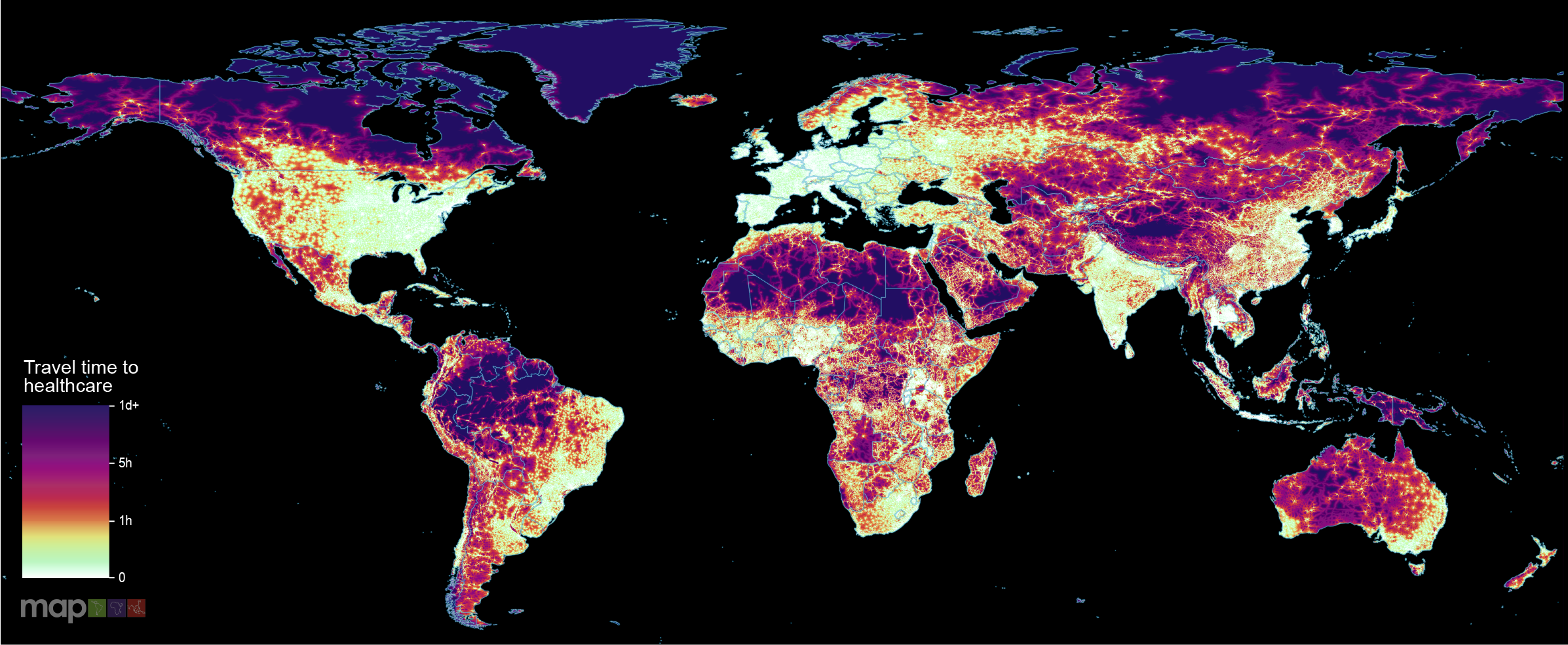
New research which maps the entire global population’s travel time to their nearest healthcare facility has revealed major inequalities in access to healthcare depending on whether people have access to motorised transport or not.
Disease spreading models such as the ubiquitous SIS compartmental model and its numerous variants are widely used to understand and predict the behavior of a given epidemic or information diffusion process. A common approach to imbue more realism to the spreading process is to constrain simulations to a network structure, where connected nodes update their disease state based on pairwise interactions along the edges of their local neighborhood.
Hepatitis B (HBV) prevalence is very high in pregnant women in the Dolpa district of Nepal, a region characterised by a remote geographic landscape and low vaccination coverage. Using mathematical modelling, we evaluated the impact of third-trimester tenofovir disoproxil fumarate (TDF) prophylaxis on HBV burden and estimated the time required to achieve HBV elimination in Dolpa.
Differential exposure and effect of malaria results from blends of biophysical, geospatial, and social determinants of health (SDoH). Likewise, effective policies and programmatic interventions against malaria must consider the complex interaction of social and spatial factors, while comprehensive health promotion approaches must simultaneously tackle SDoH and the ecological dimensions that drive malaria.
Country-level estimates can mask local geographic variations in progress toward achieving World Health Organization's End TB targets. This study aimed to identify spatial variations in progress toward achieving the TB incidence reduction target at a district level in Ethiopia.
Tuberculosis (TB) is the leading infectious cause of death globally, with approximately three million cases remaining undetected, thereby contributing to community transmission. Understanding the spatial distribution of undetected TB in high-burden settings is critical for designing and implementing geographically targeted interventions for early detection and control.
Malaria remains a leading cause of illness and death globally, with countries in sub-Saharan Africa bearing a disproportionate burden. Global high-resolution maps of malaria prevalence, incidence, and mortality are crucial for tracking spatially heterogeneous progress against the disease and to inform strategic malaria control efforts. We present the latest such maps, the first since 2019, which cover the years 2000–22. The maps are accompanied by administrative-level summaries and include estimated COVID-19 pandemic-related impacts on malaria burden.
Traditional birth attendance (TBA) remains common in Sub-Saharan Africa (SSA), impacting maternal and neonatal mortality rates. This study aimed at producing high-resolution geospatial estimates and identifying predictors of TBA-assisted childbirth in SSA.
The prevalence of taeniasis in Thailand has decreased over the past six decades. However, it remains a public health concern, particularly in focal areas, especially along the border regions where migration between Thailand and neighboring endemic countries is frequent. Spatial distribution analysis provides a useful method for identifying high-risk areas and implementing targeted integrated control measures. This study aimed to examine the spatial patterns of taeniasis in 2008 and 2014, along with their associated One Health risk factors at the sub-district level.
Worldwide, tuberculosis (TB) remains the leading cause of death from infectious diseases. Africa is the second most-affected region, accounting for a quarter of the global TB burden, but there is limited evidence whether there is subnational variation of TB prevalence across the continent. Therefore, this study aimed to estimate sub-national and local TB prevalence across Africa.